
The 2006 Research
Ministry of Culture of the Republic of Croatia gave its approval for financing the programme of protective archaeological researches at the prehistoric archaeological site of Gradac in Bapska in 2006.
The Site – Location and Form
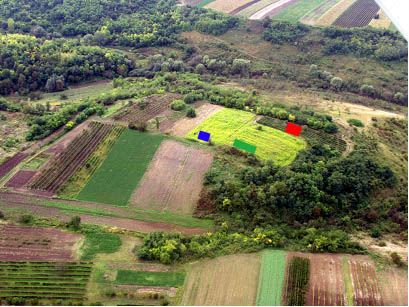
Gradac in Bapska is a multilayer prehistoric site located at an altitude of 188 metres above the sea level. It is oval in shape and it stretches in an approximate northwest-southeast direction. It is a pointed, flat protrusion of the nearby hill Fruška Gora, which itself extends in the east-west direction, that is to say perpendicularly to the presently visible shape of the site (the photographs are available in the Picture Gallery).
Prior to the most recent researches, the Gradac site was researched on three occasions, i.e.: in 1911. (Hoffiller & Vohalski), in 1938. (Schmidt) and in 1964. (Dimitrijević). The known trenches from these old researches have been depicted in Picture 1.
Picture 1
Gradac with previous research: red one denoting position of Schmidt’s soundings, blue denoting Dimitrijević’s ones, and green denoting the most recent researches commenced in 2006 (the position of the 1911 sounding is unknown)
Description of the Project
The project of a protective archaeological research of the Bapska-Gradac site has been initiated due to an extremely high level of threat to which cultural layers of the site have been exposed. Although the research started with merely symbolic surface excavations, it is already now quite clear that the entire cultural horizon (Baden culture) has been almost totally destroyed. Only sporadic surface finds, which generally may be attributed to a late period of this culture, belong to the Baden culture.
Since the site has been threatened in its entirety (Picture 2) (37.740 m2), the research is expected to last for years. The texts on the history of researches in Bapska provided positive evidence of two cultures residing at Gradac (Sopot and Vinča), and according to some authorities, it could easily be discovered that the representatives of Starčevo culture, that is to say of Early and Middle period of a local Neolithic, also abided at Gradac near Bapska. Apart from the protection of the site itself, these researches will also cast light on many questions regarding the period of a late Neolithic, which demonstrates specific characteristics in the area of Srijem. With its at least 5 metres deep stratigraphic sequence, this site is ideal for providing us with answers to these questions, which greatly surpass the significance of the Croatian archaeology alone, hence the hope that the results of these researches shall add some new pieces to a mosaic of the reconstruction of a Neolithic life in this part of Europe.
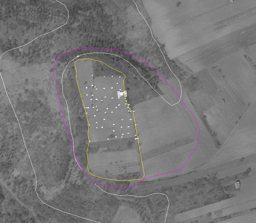
Picture 2 – A yellow colouring denotes present visible part of a Neolithic settlement, while the pink one denotes a region where the archaeological finds are visible at the surface (37.740 m2). The "pink" area has about 270 metres in "diameter". (all surveyor’s measurements at the site were carried out by Gajski & Ciceli)
Being located immediately adjacent to an exit from the village of Bapska, i.e. along the future Ilok – Bapska – Lipovac road, the site might be used as a possible tourist asset representing a vision of a prehistoric life in this area; this vision could be reconstructed with the finds discovered at Gradac. In this way the site would become a brand that could be exploited in promotion of the products and services of this particular region.
Description of the First Research Campaign
The researches have been conducted under the guidance of the Department of Archaeology of the Faculty of Arts of the Zagreb University, with the cooperation of some institutions from Croatia and abroad alike, such as:
- Faculty of Geodesy, Photogrammetry Department (doc.dr. Dubravko Gajski, mr.sc. Tomislav Ciceli, and Ana Kuveždić, undergraduate)
- Faculty of Natural Sciences and Mathematics, Institute of Analytic Chemistry (Tomislav Biljan, Assistant)
- An exchange of students has been planned in cooperation with the University of Heidelberg and Tübingen, Germany, as well as with the Thessaloniki University; the exchange has already been confirmed by the Universities of Thessaloniki and Tübingen.
A comprehensive surveyor’s plan has been prepared in the first year of the researches; it should serve as a digital platform for the computer documentation once the more extensive excavations started. This part of work has been carried out in cooperation with the Department of Photogrammetry of the Faculty of Geodesy of the Zagreb University.
For the purpose of a comprehensive data collection on frequency of certain types of finds, an area of 720 square metres of the northern plateau of the site has been scanned by use of a geo-radar method; this should expedite the planning and organising future archaeological soundings. For the same reason, detailed aerial photographing and geo-magnetic measurements have been provided, too.
This year, the research campaign partly consisted of the archaeological excavations, which lasted 12 days. During that period, 60 m2 of a humus layer has been exposed; the total surface of the B-G 06 trench being 200 m2.. Four archaeology students from Zagreb, and one high school student from Bapska took part in the research.
Stratigraphically, the finds belong to a ploughed humus layer: therefore the ceramics recovered is generally fragmented, mainly belonging to Sopot culture. A number of stone tools have been discovered: a fragment of an axe with handle hole, as well as a fragment of a partly crafted shell (spondilus?). All pieces of tools were made out of a high quality material which had been mostly imported from the present Hungarian territory (e.g. a radiolarite of the Szent Ghal type); it may be assumed that the lesser part of the material was brought in from the area of the Slavonian Mountains, or from the Fruška Gora. For more precise conclusions in this segment, we will have to wait for the results of the petrographical analyses.
Apart from the aforementioned portable finds, a portion of an architectural ruin has been discovered; it is assumed that it could be the remnant of the remnants of a collapsed house wall. The find is partly preserved in spite of the devastation due to agricultural activities in this terrain.
This detail will also be more precisely elaborated after the resumption of the research campaign planned for the Summer 2007.
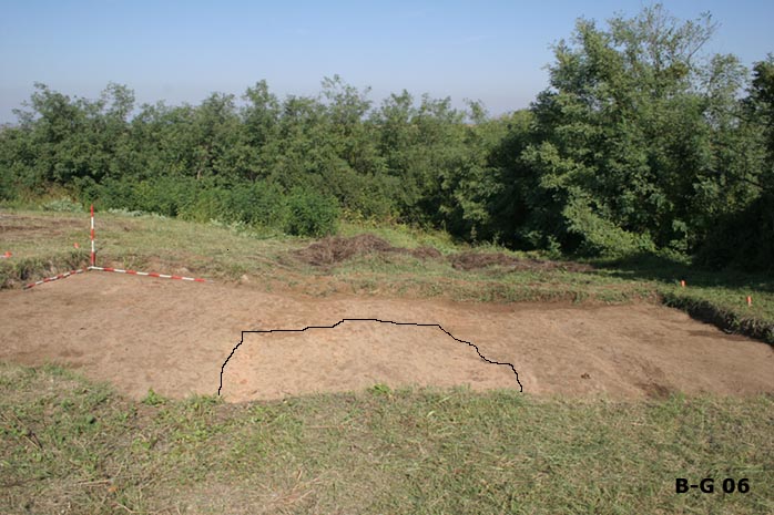
Picture 3
Excavated part of the B-G 06 sounding, with marked area of the architectural ruin (house?)
Interdisciplinary Methods
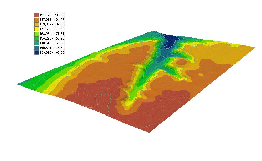
An area around Gradac, photographed by use of photogrammetric and orthophotographic methods, provides a series of information, thus rendering much better visibility of the strategic position of the site. A darker segment of a spectre in the Picture 4 depicts a furrow surrounding Gradac on three sides, showing that this area is, in fact, the beginning of a terracing ascension of the Fruška Gora. A legend on the left denotes an absolute altitude above the sea level in metres
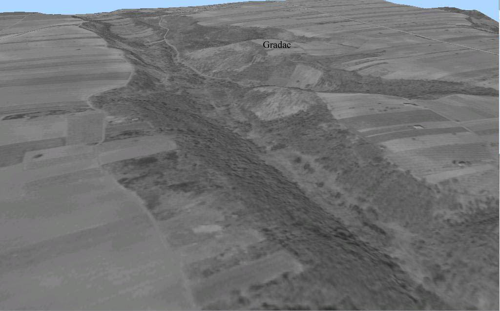
Picture 5 shows the site from a reverse angle.
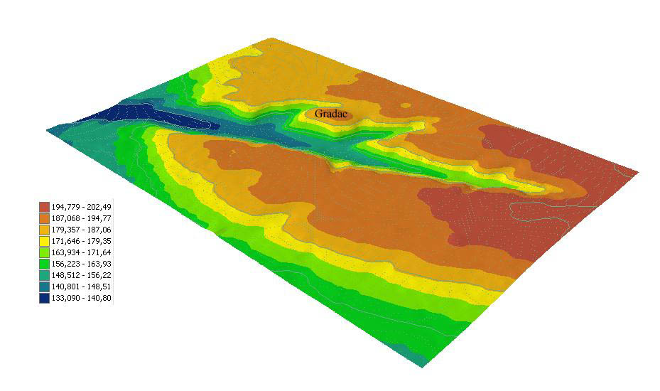
Picture 4
Perspective representation of the terrain with the hypsometric scale of colours (prepared by: Ana Kuveždić)
Picture 5
Perspective representation of the terrain with the hypsometric scale of colours (prepared by: Ana Kuveždić)
Picture 6 depicts a screenshot 3D visualisation with the designation of the site position. To see the 3D visualisation click here (5,3 MB, 3D author: Ana Kuveždić). The site can be seen at the end of the visualisation just below the centre of your screen. Picture 6 may as well illustrate the position of the site.
Geo-radar Measurements
Geo-radar measurements have also been carried out during the first research campaign at Gradac.
We have been using a geo-radar which detects solid underground structures, in this case possible remnants of walls, foundations and floors of the buildings, as well as pits or other phenomena of anthropogenic origin under the ground surface.
The researches have been carried out in the area immediately adjacent to archaeological sounding; on its south-southwest side.
Two soundings were placed, within which total of 50 geo-radar profiles were measured; they showed correlation between solid architectural or construction elements and soil substratum without solid remnants in it.
The results have been mapped, i.e. incorporated into existing plans so that they could be used for targeted archaeological excavations.
The situation thus acquired by way of geo-radar measurement enables us to distinguish solid phenomena up to 1.5 to 2 metres deep. Below this level, due to properties of soil or distribution of yet unknown anomalies, one cannot differ possible archaeological phenomena. At a relatively small depth of approximately 40 cm we can observe few anomalies which indicate possible archaeological structures.
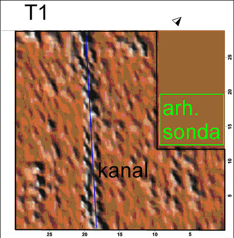
Picture 7
Layout representation of the results of measurements at the depth of about 15 cm
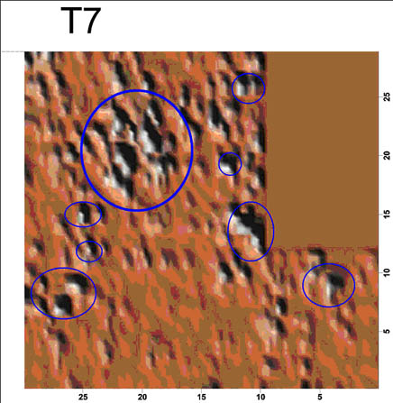
Picture 8
Layout representation of the results of measurements at the depth of about 70 to 80 cm
Sponsors of the Project:

![]()
www.hoteldunavilok.com www.splitskabanka.hr
posted: 15. 11. 2006.
© copyright Department of Archaeology, University of Zagreb
web: M. Burić
English Translation: S. Čule